
Nonprofits face myriad challenges when it comes to retaining staff. If leadership added routine hikes through rough mountainous terrain, near-impenetrable swamplands, raging fires or war zones to junior associates’ duties, there would be a stampede toward the exits.
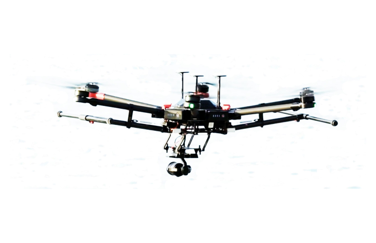
Such trips, however, are essential to many nonprofits’ missions. Enter unmanned aerial vehicles, or drones, as they are more commonly known. “UNICEF uses drones for the movement of cargo, especially vaccines and time and temperature-sensitive medicine in scenarios with limited cold-chain, aerial mapping for emergency preparedness and response, and broadcasting of internet communication services in emergency scenarios where service is not available,” said Edmond Nonie, drone specialist within the Stockholm-based Office of Innovation in the United Nations Children’s Fund.
Drones also track changing conditions for hazards such as mosquito breeding grounds or locust migration patterns, allowing the agency to quickly spray or otherwise treat threatening conditions.
Drone deliveries are especially important within the rougher terrain of rural last-mile, hard-to-reach places such as the South Pacific Ocean Island nation of Vanuatu or the African nation of Malawi. In one Malawian locale, a healthcare worker travels 16 kilometers to acquire supplies and bring them back to the community he serves. That journey doubles in rainy season because prior to it he can he cut across a dry river. Without him making that trip, his community doesn’t get health supplies.
Absent those supplies, which include treatments as well as vaccines, maladies can take root very quickly. The speed of a drone trip (less than 20 minutes one way, in the above example) means items requiring refrigeration can be delivered before they get too warm for use.
UNICEF has operated a drone test corridor within Malawi airspace since 2017. The 5,000-square kilometer region, which also extends 400 meters above ground level, allows individuals, industries, organizations and universities to test use cases for humanitarian efforts. The organization also operates done test corridors in Kazakhstan, Sierra Leone and Vanuatu and will be establishing drone corridors in Mozambique and Namibia during the first half of 2023, Nonie said.
But setting up African drone programs has been challenging. People who can operate drones and analyze the data were in scarce supply. UNICEF responded in 2020 by sponsoring its first African Drone and Data Academy in Malawi.
The program is run by Virginia Tech’s Center for International Research, Education, and Development in conjunction with the Malawi University of Science and Technology. The 11-week certificate curriculum includes making, testing and flying drones and technology entrepreneurship and analysis of drone-gathered data, including an introduction to geographic information systems (GIS). The program was expanded in 2022 to include a Master’s degree. To date, more than 900 people from at least 20 African nations have completed at least one form of training. A majority of the students (60%) is female.
UNICEF does not have any U.S.-based drone operations, but plenty of other domestic nonprofits employ them. Employees at The Virginia chapter of The Nature Conservancy, Charlottesville, Virginia, are using drones for everything from following migration patterns to mapping topographical changes to aiding in controlled forest burns. It is being done at a fraction of the cost — and risk — traditional missions entail.
Drones provide high-resolution updates as the shape of marshes and beaches change within the Delmarva Peninsula around Maryland, Delaware and Virgina. “As the climate changes, it’s important for us to pay attention to how those islands are moving,” said Sam Lindblom, the chapter’s director of landscape conservation. “It has huge implications for all kinds of wildlife out there. And the eastern shore is one of the most important flyways for migratory birds in the eastern United States.”
Drone use allows the organization to map and photographically capture changes without relying on government or commercial images. “The problem with those is that they are typically not the resolution we want,” Lindblom said. “Zoom in enough and everything gets pixilated. If it happens to be a cloudy day, the imagery is useless.”
For The Nature Conservancy, drones are more than an eye or camera in the sky. Toward the central part of the state, such as the Virginia Pinelands and the central Appalachians region, drones are an integral part of fire management work, including prescribed burning activities.
The basic image-and-mapping drones The Nature Conservancy uses are also relatively inexpensive. Simple drone/camera/control panel systems can run in the mid-four-figures. But those drones have limited flight ranges and durations, and carry minimal payloads, such as lightweight cameras.
The fire management drones are another beast entirely. The fire management drone used by The Nature Conservancy is the Matrice 600 Pro. The unit supports a takeoff weight of up to 33 pounds, which gets used up quickly once stabilizing gimbals and a camera that can provide imagery through smoke are added. And that’s before the heart of the fire management activities, an Ignis dispenser that carries up to 450 ignitable plastic spheres, is included. One fully kitted-out system, including the ground-based control systems for the various components, can run around $70,000, according to Lindblom.
The price of a non-fire management drone is cheap, however, in comparison to other data-gathering methods, which can involve time-consuming hikes or drives, methods that do not lend themselves to surveying rough terrain. Higher-altitude missions, whether reconnaissance or fire management, involve commissioning a helicopter. “That is incredibly expensive per picture, and dangerous, because you have to fly really slow, with a really low elevation,” Lindblom said.
Fire-management activities are also less expensive when drones are used. A day’s worth of burn missions might cost the organization around $6,000, Lindblom estimated. For the price of 10 such missions, the organization can buy a drone, which also drastically reduces risk. “Prescribed fire work is dangerous,” Lindblom said. “There’s no question about it.”
The drones currently in use are older, at least as drone technology goes. As currently configured, the drones don’t transmit information while in flight. The risk of losing a day’s work — to say nothing of the unit itself — means drone flights occur under fairly strict, mostly weather-related, parameters. “We have lost one drone in the last decade of doing this,” Lindblom said. “We tried to land the drone on a boat, and the drone clipped the edge of the boat and went into the water. But we didn’t lose the drone, and we got the SD card.”
The Virginia chapter of The Nature Conservancy employs half a dozen pilots for its drone work, fire-related and otherwise. None of the pilots is full-time. Their activities are supplemented by GIS (geographic information systems) analysis and other duties. And between maintenance, expanded information and capabilities and the analysis these entail, drone-aided activities do not offer a lot in the way of labor savings, according to Lindblom.
Some nonprofit managers acknowledge the power of drones even without using them firsthand. Nashville, Tennessee-based Drones for Good Worldwide was founded in April 2022 by tech and travel entrepreneur Joe Freedman. To date, the organization has sent more than 200 drones to a non-government humanitarian organization in Ukraine.
“I sit on a board of a company that sells drones,” Freedman said. “We were contacted by some pilots [in Ukraine] who told us when the war started the drones they were using were grounded, because they are Chinese manufactured. The manufacturer did something with the GPS that disabled the drones.” When the drones were re-enabled, Russian soldiers were able to determine their launch location, Freedman added.
Freedman was skeptical, but a trip to Ukraine to meet the organization leaders convinced him of the claim’s veracity. He and a friend immediately established a website to solicit donations for the purchase and transportation of drones.
Individuals at several of the tech firms Freedman works with determined which components were allowing the manufacturer to ground the drones and figured out how to disable those components on the first dozen drones his organization provided. Since then, the Ukraine organization’s pilots have determined which models are most easily modified, and Drones for Good Worldwide purchases and ships those.
Freedman is adamant that the drones his organization provides are for humanitarian purposes. Most of the $800,000 Freedman said his organization has raised — it is too new to have financial information on file with the Internal Revenue Service — has been used for lower-end lightweight models. These drones, which run around $1,200, have limited payloads: they can carry cameras, for instance, but not the Ignis dispenser that transports combustible plastic balls used by The Nature Conservancy. Good Worldwide did purchase one rugged $22,000 drone capable of flight in rough weather, as well as a few mid-range drones with thermal imaging capabilities.
“They do search and rescue. They do refugee safe passage. They can identify where a building is burning, they can identify people under rubble,” Freedman said of the lower-end units.
Drones for Good Worldwide’s activities have gone beyond providing technology. When the organization has room on its cargo pallets, it includes donated items such as winter clothes. And Freedman was able to help both a drone pilot, as well as two of the translators from his trip, relocate from Ukraine and Poland to Brooklyn. He stressed that 90% of the money raised has gone toward drone purchase, and the quantities have been augmented by donated material.
For now, the organization’s focus is on the war in Ukraine. But when the conflict is over, it will continue to provide disaster relief-equipped drones throughout the world, Freedman said.